


توضیحات Hiking Slovakia - Tourist Map
Hiking app covering the area of Slovakia. A must-have for every hiker.
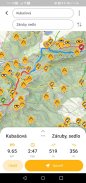
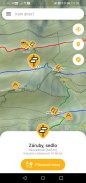
• All marked hiking trails and junctions
• Large database of peaks, viewpoints, picnic or camping sites, castles, caves, water sources, shelters or accomodations
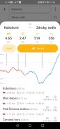
• Elevation and contour maps with scale
• Ability to download maps to phone and use them offline
• Indication of current location
• The distance to any point
• Search among the junctions and other points of interest
• Augmented reality for better orientation in the terrain
• Compass
Warning: If you like being lost, love adrenaline and survival, don't get this app... ;-)
Required permissions: location (see the current position on map), Internet access (maps), access to the SD card (locally stored maps), camera (augmented reality)
The application uses freely available data from projects freemap.sk and openstreetmap.org
Hiking نرم افزار پوشش منطقه از اسلواکی. برای هر کوهنورد باید داشته باشند.
• همه مسیرهای پیاده روی مشخص شده و اتصالات
• بانک اطلاعاتی بزرگ از قله، نظرات، پیک نیک و یا کمپینگ سایت ها، قلعه ها، غارها، منابع آب، پناهگاه و یا اتاق
• ارتفاع و شکل نقشه ها با مقیاس
• قابلیت دانلود نقشه ها به گوشی و استفاده از آنها نیست
• نشانه ای از مکان فعلی
• فاصله به هر نقطه
• جستجو در میان اتصالات و سایر نقاط مورد علاقه
• واقعیت افزوده برای جهت گیری بهتر در زمین
• قطب نما
هشدار: اگر دوست دارید از دست داده، عشق آدرنالین و بقا، آیا این برنامه نیست ... ؛-)
دسترسی مورد نیاز: محل (موقعیت فعلی روی نقشه)، دسترسی به اینترنت (نقشه)، دسترسی به کارت SD (نقشه به صورت محلی ذخیره)، دوربین (واقعیت افزوده)
این برنامه با استفاده از داده آزادانه در دسترس از پروژه های freemap.sk و openstreetmap.org
Hiking Slovakia - Tourist Map - نسخه 3.0.10
(26-03-2022)
Hiking Slovakia - Tourist Map - اطلاعات APK
نسخه APK: 3.0.10حزمة: sk.archae.hiking.androidاپلیکیشنها در دسته مشابه
شاید دوست داشته باشید...


